
When Cyclone BiparjoySaurashtra‑Kutch Coast, Gujarat slammed into the India‑Pakistan border region on June 15, 2023, the India Meteorological Department (IMD) sounded the alarm and the state of Gujarat mobilised an unprecedented evacuation effort.
Background and Meteorological Build‑up
The story began on June 6, when the India Meteorological Department logged a weak depression over the Arabian Sea. Within hours the system intensified, and by June 12 it had earned the classification of a "very severe cyclonic storm". The IMD issued its first advisory to Gujarat officials, warning of sustained winds that could reach 115‑125 km/h at landfall.
Why did Biparjoy linger for a record‑breaking ten days? Raghu Murtugudde, a visiting professor at the Indian Institute of Technology‑Bombay, explained that the storm fed on unusually warm Arabian Sea waters, a symptom many scientists link to climate change.
Landfall Impact and Immediate Response
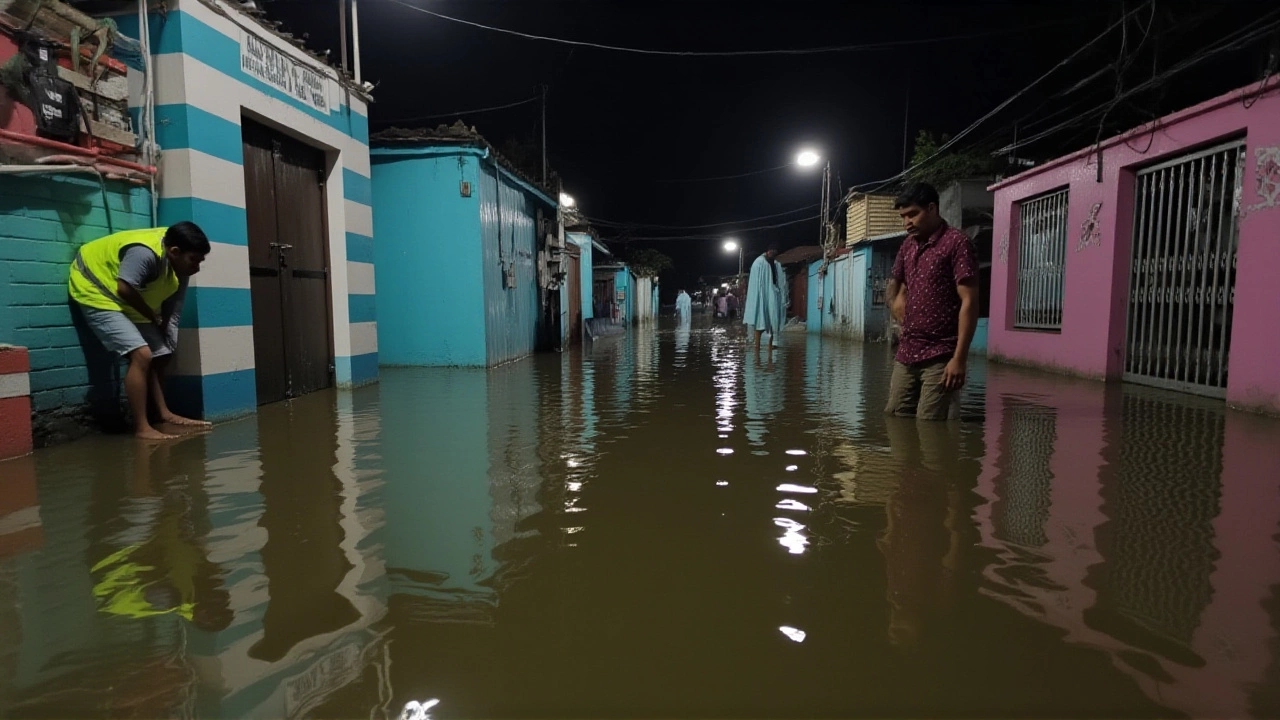
At approximately 6:00 PM local time, the cyclone made landfall between Karachi and Mandvi, tearing across the Saurashtra‑Kutch coastline. Gusts peaked at 140 km/h, equivalent to a Category 2 hurricane on the Saffir‑Simpson scale.
Gujarat's chief minister, Bhupendra Patel, ordered the deployment of national and state disaster‑response teams. In the end, more than 150,000 residents were moved to shelters, a feat described by local officials as "one of the largest evacuation operations in the state's history".
The immediate damage was stark: at least 23 people suffered injuries, 12 fatalities were confirmed, and power outages plunged 4,600 villages into darkness. Coastal roads were flooded, and wind‑borne debris damaged homes across Kutch and Saurashtra.
Heat‑wave Mitigation and Climate Context
While the cyclone wreaked havoc on the coast, its remnants played an unexpected role in the broader weather picture. A June 2023 heat wave had scorched northern India, pushing temperatures above 45 °C in parts of the Indo‑Gangetic Plain. The Mausam Journal, published by the IMD, noted that Biparjoy's lingering circulation disrupted a persistent mid‑to‑upper tropospheric ridge, allowing cooler air to surge southward.
According to the journal, maximum temperatures fell by 3‑6 °C across Rajasthan and western Madhya Pradesh within 48 hours of landfall. The drop gave heat‑stroke patients a brief reprieve and gave farmers a chance to protect crops from lingering scorch.
"Rain from this system can reach Rajasthan and western Madhya Pradesh this weekend," warned Nicholls, a meteorologist with AccuWeather. The anticipated showers are expected to arrive after the storm has weakened to a deep depression, but the cooling effect is already evident.
Human Toll, Damage and Recovery Efforts
- 12 confirmed deaths across Gujarat and neighboring states.
- 23 injuries ranging from minor cuts to broken bones.
- Power loss in 4,600 villages, with restoration efforts underway.
- Over 150,000 evacuees housed in government‑run shelters.
- Economic loss estimates pending, but early assessments suggest damages in the hundreds of millions of dollars.
Relief agencies, including the National Disaster Response Force (NDRF), dispatched medical teams, clean water supplies, and temporary power generators. By June 19, the IMD downgraded Biparjoy to a well‑marked low‑pressure area, and the focus shifted to rebuilding roofs, restoring electricity, and assessing agricultural losses.
Looking Ahead: Forecasts and Lessons Learned
Scientists are already poring over the Biparjoy case to refine future forecasts. The Mausam Journal article "Tropical Cyclone 'Biparjoy': a blessing in disguise for the disastrous heat wave event of June 2023 over India" argues that Arabian Sea cyclones can act as a natural thermostat, moderating heat extremes after landfall. The authors urge policymakers to integrate cyclone trajectory models into heat‑wave preparedness plans.
Meanwhile, climatologists caution that longer‑lasting storms like Biparjoy may become more common as ocean temperatures rise. The event underscores the need for resilient coastal infrastructure, faster evacuation protocols, and better public communication.
Key Facts
- Landfall: June 15, 2023, 6:00 PM local time.
- Peak winds: 115‑125 km/h sustained, 140 km/h gusts.
- Evacuated: >150,000 people from Gujarat’s coastline.
- Deaths: 12 confirmed; Injuries: 23.
- Heat‑wave temperature drop: 3‑6 °C across northern India.
Frequently Asked Questions
How did Cyclone Biparjoy affect the ongoing heat wave in India?
The cyclone’s remnant circulation disrupted a high‑pressure ridge that had trapped hot air over the Indo‑Gangetic Plain. As a result, temperatures in Rajasthan and western Madhya Pradesh fell by 3‑6 °C within two days of landfall, providing temporary relief from the lethal heat wave.
What measures did Gujarat’s government take before the storm hit?
Chief Minister Bhupendra Patel ordered the activation of the State Disaster Management Authority, mobilised the National Disaster Response Force, and coordinated with the IMD to issue early warnings. Shelters were prepared, and more than 150,000 residents were evacuated from vulnerable coastal villages.
Why did Biparjoy last longer than typical Arabian Sea cyclones?
Researchers, including Prof. Raghu Murtugudde, point to unusually warm sea‑surface temperatures in the Arabian Sea, which supplied ample heat energy. This, combined with weak vertical wind shear, allowed the system to maintain intensity for about ten days—surpassing the previous record set by Cyclone Kyarr in 2019.
What are the expected weather conditions for Rajasthan and Madhya Pradesh after the cyclone?
AccuWeather meteorologist Nicholls predicts showers throughout the weekend, with rainfall totals of 30‑50 mm. The moisture should keep temperatures below 35 °C for several days, helping to curb the lingering heat‑wave effects.
How will this event influence future cyclone and heat‑wave forecasting in India?
The Mausam Journal’s analysis suggests that integrating cyclone trajectory data into heat‑wave models could improve early‑warning capabilities. Policy makers are now urged to consider tropical cyclone forecasts as part of comprehensive heat‑wave mitigation strategies.